Ai3Dr Benchmark
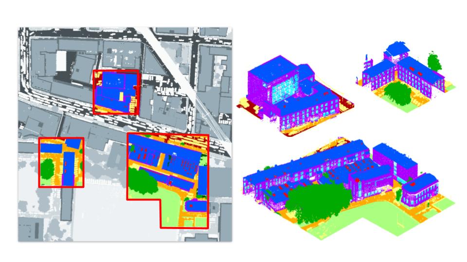
Ai3Dr is a novel benchmark to evaluate 3D reconstruction methods using aerial images in a large-scale urban scenario. In particular, it presents an evaluation of open-source state-of-the-art pipelines for image-based 3D reconstruction including, for the first time, an analysis per urban object category. Therefore, the standard evaluation presented in generalist image-based reconstruction benchmarks is extended and adapted to the city. Furthermore, our benchmark uses the densest annotated LiDAR point cloud available at city scale as ground truth and the imagery captured alongside.
Paper
Bibtex
Please cite our work if you use this benchmark along with the corresponding citations for the data sources.
@conference{visapp21,
		author={Susana Ruano. and Aljosa Smolic.},
		title={A Benchmark for 3D Reconstruction from Aerial Imagery in an Urban Environment},
		booktitle={Proceedings of the 16th International Joint Conference on Computer Vision,
				Imaging and Computer Graphics Theory and Applications - Volume 5: VISAPP,},
		year={2021},
		pages={732-741},
		publisher={SciTePress},
		organization={INSTICC},
		doi={10.5220/0010338407320741},
		isbn={978-989-758-488-6},
		}
@inproceedings{zolanvari2019dublincity,
  		title={DublinCity: Annotated LiDAR Point Cloud and its Applications},
		author = {S.M. Iman Zolanvari and Susana Ruano and Aakanksha Rana and Alan Cummins
				and Rogerio E. da Silva and Morteza Rahbar and Aljosa Smolic},
  		booktitle={30th British Machine Vision Conference (BMVC)},
  		year={2019}

}
@article{laefer20172015,
  		title={2015 aerial laser and photogrammetry survey of Dublin city collection record},
  		author={Laefer, Debra F and Abuwarda, Saleh and Vo, Anh-Vu and Truong-Hong, Linh and Gharibi, Hamid},
  		year={2017}
}
Contact
Contact the benchmark administrator is you have any question about it.